Enregistrez gratuitement cette image
en 800 pixels pour usage maquette
(click droit, Enregistrer l'image sous...)
|
|
Réf : T01772
Thème :
Terre vue de l'espace - Plaines - Plateaux - Vallées - Général (487 images)
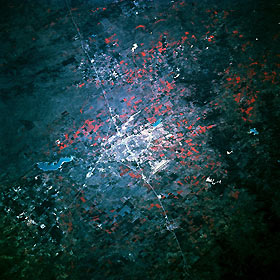
Titre : Abilene, Texas, U.S.A. March 1994
Description : (La description de cette image n'existe qu'en anglais)
Abilene, surrounded by agricultural and pasture lands (shown in red) and bordered on the north by Interstate Highway 20, lies on a flat plain in the eastern Permian Basin. Viewing clockwise from U.S. Highway 83, which leads northwest from the city, are Fort Phantom Hill Lake, Abilene Municipal Airport southeast of the city, and Dyess Air Force Base to the southwest. South of Abilene, dark Callahan Divide, a high, flat-topped ridge of limestone, extends in an east-west orientation paralleling Interstate Highway 20.
|
|

